


Le tour du Char des Quais

micheldutilleul
User
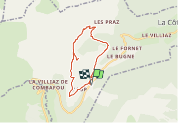

Length
6.4 km

Max alt
1670 m

Uphill gradient
287 m
Km-Effort
10.2 km

Min alt
1430 m

Downhill gradient
288 m
Boucle
Yes
Creation date :
2025-05-20 09:45:49.042
Updated on :
2025-05-20 10:10:14.421
2h18
Difficulty : Medium

FREE GPS app for hiking
 SityTrail
IGN / Geographical institutes
SityTrail Plus
The world is yours!
About
Trail Walking of 6.4 km to be discovered at Auvergne-Rhône-Alpes, Upper Savoy, La Côte-d'Arbroz. This trail is proposed by micheldutilleul.
Positioning
Country:
France
Region :
Auvergne-Rhône-Alpes
Department/Province :
Upper Savoy
Municipality :
La Côte-d'Arbroz
Location:
Unknown
Start:(Dec)
Start:(UTM)
317370 ; 5115935 (32T) N.
Comments